


Lac de la Thuile-2022-G2

Valmeinier
User
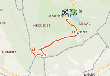

Length
8.5 km

Max alt
1130 m

Uphill gradient
284 m
Km-Effort
12.3 km

Min alt
889 m

Downhill gradient
282 m
Boucle
Yes
Creation date :
2022-05-22 17:47:31.349
Updated on :
2022-05-22 18:00:55.402
2h47
Difficulty : Difficult

FREE GPS app for hiking
 SityTrail
IGN / Geographical institutes
SityTrail Plus
The world is yours!
About
Trail Walking of 8.5 km to be discovered at Auvergne-Rhône-Alpes, Savoy, La Thuile. This trail is proposed by Valmeinier.
Photos


Positioning
Country:
France
Region :
Auvergne-Rhône-Alpes
Department/Province :
Savoy
Municipality :
La Thuile
Location:
Unknown
Start:(Dec)
Start:(UTM)
269889 ; 5046045 (32T) N.
Comments